Mobility Studies

Purple-Modern-Professional-Web-Designer-LinkedIn-Banner.png


Indianola Avenue Complete Streets

INDIANOLA AVENUE COMPLETE STREETS STUDY

UPDATES - APRIL 2024
Indianola Avenue will be repaved and restriped in 2025 as part of an urban repaving project in partnership with the Ohio Department of Transportation. The project was originally scheduled for 2024, but has been delayed due to right-of-way acquisition for sidewalk repairs that were added to the project. Some sections of sidewalk are outside of the city’s public right-of-way and must be purchased from adjacent landowners in order to be replaced.


PROJECT OVERVIEW

In response to public feedback, the section between Weber Road and Midgard Road will be reconfigured to accommodate additional on-street parking spaces, while still maintaining continuous bike lanes. The two-way left turn lane will be removed in this section to allow for more on-street parking spaces to serve local businesses. A northbound buffered bike lane will be added between Hudson and Arcadia, connecting to an existing bike lane on the west side of Hudson Street. An existing bike route on Arcadia Avenue will connect the Indianola bike lanes to the Summit Street cycle track. Bike lanes will continue north of Arcadia Avenue to Oakland Park Avenue. With the new configuration, 48 on-street parking spaces will be available to patrons, residents, and visitors between Weber Road and Midgard Road. ADA Accessible Parking spaces, loading zone spaces, and bike parking will also be designated within the business district, though the number of spaces is yet to be determined. All on-street parking spaces on Indianola Avenue will be available at all times of the day, without peak time restrictions.

The addition of bike lanes on Indianola Avenue will fill a significant network gap and provide over 7 miles of continuous bike facilities from Downtown to Morse Road. Reducing the number of travel lanes and providing a bike facility will also help to improve safety and meet the goals of Vision Zero Columbus. Sidewalks between Weber Road and Midgard Road will be improved primarily on the east side of Indianola Avenue. Additional sidewalk locations will be assessed for improvement on the west side of Indianola Avenue north of Milford Avenue. High visibility crosswalks will be added at Cliffside Drive, Crestview Road, Milford Avenue, Walhalla Road, and all signalized intersections between Hudson Street and Oakland Park Avenue. Two bump-outs will be added at Milford Avenue and on the west-side of Indianola Avenue at Crestview Road and Walhalla Road.

ABOUT THE STUDY
The Indianola Avenue Complete Streets Study area encompasses portions of Clintonville and the University District. Indianola Avenue, also designated as U.S. Route 23, is a major thoroughfare traversing north and south in the north central region of the city. The study will examine the current traffic conditions in the corridor, taking into consideration connections to non-motorized transportation uses such as trails, sidewalks, and bikeways. A complete streets approach will balance the needs of different roadway users to:

  • Create a design that encourages motorists to drive at safe and reasonable travel speeds
  • Improve the pedestrian experience and create better bikeway connections
  • Accommodate safe and reliable transit service through the corridor
  • Develop a parking strategy that reasonably meets the needs of businesses, patrons, and residents


Documents:

Study Area Map(PDF, 940KB)
Frequently Asked Questions(PDF, 853KB)
Capacity Analysis(PDF, 24MB)
Supplemental Parking Observations Memo(PDF, 14MB)
Draft Conceptual Drawings(PDF, 1MB)
Clintonville Area Commission Meeting Presentation Slides, 12-2-21(PDF, 2MB)
Safety Evaluation(PDF, 19MB)Parking Utilization Memo(PDF, 3MB)
Public Meeting Slides 9/16/21(PDF, 5MB)
Public Meeting Comments 9/16/21(PDF, 362KB)
Public Engagement Report(PDF, 6MB)
Indianola Project Updates – June 2022(PDF, 3MB)


Public Comments:

The public comment period has closed. If you have comments or questions about the study, please email Indianola@columbus.gov or call 614-645-3111.

RTMC Mobility Study

ABOUT THE STUDY

The Renner Rd/Trabue Rd/McKinley Rd corridor (RTMC) serves multiple communities on Columbus west side. Additionally, it provides connectivity to Downtown Columbus, US-33, I-70, and I-670. Like many corridors across the city of Columbus, the RTMC corridor is experiencing significant growth and development brining increased pressure on the transportation network.

In response to these growing pains, as well as pre-existing challenges on the corridor, the City of Columbus is undertaking a mobility study that will comprehensively and holistically study the corridor. This study will result in realistic strategies, both long term and short term, to support the areas continued economic vitality, improve health and safety, and access to employment opportunities.

The RTMC Mobility Study will be completed in two phases. Phase 1 was completed in late fall 2021. Phase 2 is currently underway and is expected to be completed by spring 2023.

Documents:

Study Area Map(PDF, 1MB)
Public Presentation Slides (February 2021)(PDF, 3MB)
Part 1 Memo(PDF, 67MB) 

Public Comments:

Please submit public comments here or email RTMC@columbus.gov. If emailing, please provide your name and contact information. Anonymous comments will not be accepted.


Eastmoor Blvd Safety And Mobility Improvements

EASTMOOR BLVD SAFETY AND MOBILITY IMPROVEMENTS


ABOUT THE STUDY

 
Eastmoor Blvd (Main St to Broad St) was studied from November 2021 through November 2022 due to resident concerns with speeding. The study aimed to improve safety, reduce vehicle speeds, and accommodate non-motorized users. The overall result of the study is a plan for the roadway to improve safety for all users and provide more options for active transportation users.

The existing conditions study report, final preferred alternative, all-way stop control warrants memorandum, and public meeting slides can be found in the documents tab below.


PUBLIC ENGAGEMENT

 
The project team presented initial findings and potential design solutions at the Eastmoor Civic Association’s Semiannual Community Meeting on Wednesday, May 11, 2022. This meeting was advertised through the Civic Association and through flyers placed at every household on Eastmoor Blvd in the study area.

At that time, we received the following public feedback:

·       Speeding is a concern

·       Want slower traffic to be able to walk and bike

·       Important to maintain the character of the street

·       Desire four-way stop at Fair Ave

·       Concern over loss of parking and drainage impacts

Following the May meeting, the project team developed several alternatives including a preferred alternative that most closely aligned with the public feedback and presented these at the Eastmoor Civic Association Meeting on November 2, 2022. The preferred alternative consisted of striping changes to visually narrow the roadway to reduce vehicular speeds so that people could still walk and bike on-street, while also maintaining a majority of the on-street parking.


ALL-WAY STOP CONTROL ANALYSIS


An evaluation was completed for the intersections of Eastmoor Boulevard & Fair Avenue and Eastmoor Boulevard & Bexley Park to determine if the traffic circles could be removed and All-Way Stop Control be installed. Section 2B.07 of the Manual on Uniform Traffic Control Devices (MUTCD) contains volume thresholds that should be met to warrant multi-way stop control.  Based on this analysis, All-Way Stop Control is not warranted at these two intersections and is not recommended. The All-Way-Stop-Control Warrants memorandum can be found in the Documents tab below.


UPDATES


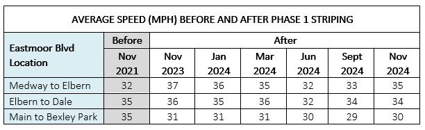
The first phase of the preferred alternative was implemented in fall of 2023. The primary goal for the first phase is to visually narrow the roadway with painted lines to reduce vehicle speeds. The City is monitoring traffic speeds following the striping changes (average speeds shown below). The medium and long term solutions following the striping changes include installing medians and/or speed humps – however, this would require additional community support and a funding source.


The City will be continually collecting speed and volume data on Eastmoor Blvd to track the impacts of the restriping project throughout 2024 to inform future design decisions. The table below shows 24-hour counts for a typical day in the month and year listed.


Eastmoor-Blvd-Average-Speeds-Jun-2024.png


DOCUMENTS

(PDF, 1MB)

Study Area Map(PDF, 1MB)
Public Meeting Slides 5.11.22(PDF, 5MB)
Public Meeting Slides 11.2.22(PDF, 2MB)
Existing Conditions Report 2022(PDF, 19MB)
Final Preferred Alternative 2022(PDF, 1MB)
All-Way-Stop-Control Warrants Memorandum 10.21.2022(PDF, 3MB)


Gender Road Corridor Mobility Study

GENDER ROAD CORRIDOR MOBILITY STUDY

About the Study

The City of Columbus along with a consultant team led by MS Consultants is beginning a study of the Gender Road corridor.  This study will develop a plan for improvements to the Gender Road corridor from Winchester Pike to Brice Road. The study includes transportation and traffic research, traffic analysis, and a feasibility study to result in projects that will improve safety, implement complete street improvements, and accommodate future development.

We need your help!  Your input will help shape the corridor’s future design.  Please take a few minutes to let us know your thoughts about traveling along Gender Road.  This survey will take about 5 minutes and your responses will remain anonymous.  Information gathered in this survey will assist the consultant team by identifying issues as well as opportunities for improvements along the corridor.  Results will be shared in a public meeting planned for early spring 2023.

If you have comments or would like to share information, please submit public comments here on the study.